METROPARKS TOLEDO
The Towpath Trail, which is is part of the Buckeye Trail (marked with blue blazes), follows the remains of the Miami and Erie Canal along the old tow path where mules towed flat-bottom boats along the waterway.
Trees along the trail are typical of floodplains and include cottonwood, sycamore, buckeye, basswood and walnut. Numerous red bud trees put on quite a show of pink blossoms in early May. Deer, raccoon, red fox, woodchuck, weasel and many other species of animals can be seen. Careful observers may even be treated to the noisy king fisher, magnificent osprey or even an occasional bald eagle. It is also an excellent corridor for viewing migrating warblers in spring.
University Parks Trail The six-mile trail stretches from the University of Toledo campus to King Road in Sylvania Township. It offers a lush green-way through woodland, passing meadows and wetlands. The level, paved path is suitable for joggers, cyclists and in-line skaters, and can easily accommodate wheelchairs.
The trail has several neighborhood access points, a trail connecting to the Wildwood Preserve Metropark trail system, and designated roadway connections to Ottawa Park, Olander Park and Westfield Shopping-center at Franklin Park.
The University Parks Trail is owned by Lucas County and maintained by Metroparks, the University of Toledo and the City of Toledo. Metroparks rangers and, in some sections, local jurisdictions patrol the trail.
Special permits are issued for commuters using the University/Parks Trail after regular park hours. To download a permit, use the link to the right.
Parking:
Tam-O-Shanter
McCord Road
Wildwood Preserve
Ottawa Hills Municipal Building
University of Toledo Southwest Academic Center
Ottawa Park
Contact: Wildwood Preserve Metropark
Office: 419-407-9700
Ranger Cell Phone: 419-270-7500
UNIVERSITY PARKS TRAIL
Wabash Cannonball Trail – Northwest Ohio’s premier rails-to-trails project is also one of the longest in the state, stretching 64 miles through four counties and Oak Openings, Ohio’s most unique natural area.
The trail follows two former rail lines forming a North Fork and South Fork, which converge at Jerome Road in Maumee, near the Fallen Timbers Battlefield.
The North Fork runs east and west for 46 miles, from Maumee to Montpelier, Ohio, coming within 15 miles of the Indiana state line. It is paved to the Lucas County border. A paved connection links the Wabash Cannonball with the 5.3-mile Oak Openings Preserve all-purpose trail.
The South Fork takes a southwesterly route, running 17 miles from Maumee to the edge of Liberty Center, Ohio. It passes through the Village of Whitehouse and the Maumee State Forest. The south fork is paved to the Lucas County line.
The trail is connected to the Fallen Timbers Battlefield on Jerome Road, and to the Fallen Timbers Monument and Side Cut Metropark via a bike-pedestrian bridge over US 24. A recent extension of the trail parallels River Road through Side Cut.
Where the paved sections of the trail end, the remainder has a railroad cinder ballast base, which is suitable for mountain bikes and horses.
The Wabash Cannonball Trail is a project of Metroparks, the Board of Lucas County Commissioners, Lucas County Engineer, the Village of Whitehouse, the City of Maumee and the Northwest Ohio Rails To Trails Association. Metroparks rangers and, in some sections, local jurisdictions, patrol the trail within Lucas County.
Parking:
Monclova Elementary School, Monclova Road
Village of Whitehouse
Oak Openings Preserve—Springbrook Area
Maumee State Forest
Fallen Timbers Monument, US 24 (connected by bridge)
Wabash Cannonball Trail North
Wabash Cannonball Trail South
Chessie Circle Trail starts on Glanzman Road across from Beverly Elementary School, crosses Detroit Avenue and continues for more than a mile to River Road. Along the way, it crosses a new bike/pedestrian bridge over the Anthony Wayne Trail.
Named for the railroad that once used the corridor, the Chessie Circle will one day extend for 11 miles, connecting North and South Toledo and the University of Toledo main campus with the UT Health Science campus.
Color:
Length: 1.5 miles
Width: 16 feet
Traffic: Moderate
Bikes Allowed: Yes
Accessible: Yes
Use: Shared Use
Chessie Circle Trail
This new 12-mile singletrack trail for mountain bikes is open for use. With six bridges and unique obstacles, such as an optional teeter-totter bridge, this trail is unlike any other in the Metroparks.
Start at the Springbrook Area on SR 64 and follow the Wabash Cannonball Trail east to the start of the Beach Ridge Bike Trail.
Color:
Length: 12 miles
Width: 18 inches
Traffic: Light
Bikes Allowed: Yes
Accessible: No
Use: Shared Use

Toledo Parks & Recreation Department
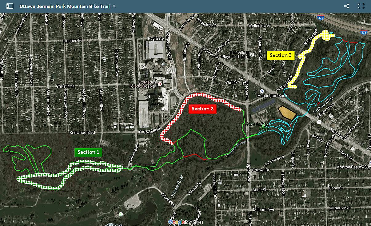
The very first Mountain Bike Park in NW Ohio is in Jermain Park, Toledo, and is free to use. The first section was designed and constructed in 2010 using mostly volunteer labor to originally create a 3.2 mile trail of beginner to low intermediate skill level. The trail-head is directly opposite the tennis courts at Jermain Park just off Upton Ave. The first section is a series of switchbacks twists and turns with negligible elevation changes. After going under the Monroe Street bridge, there is a series of inter-loops with shortcuts. The higher skill level trail section is on the far side of this area with a switchback climb to the top and then a series of roller-coaster style ups and downs before returning under the bridge back to the trail-head. The driving force behind this is a group called Toledo Free Ride.
The newest section, opened in 2012 & 2013, increased mileage to 6.4. It has more intermediate climbing, downhill, and off-camber riding in Ottawa Park. This section can be accessed from the trail-head and then heading west under the Upton Street bridge. The only Jump Park in Toledo (dirt jumps and pump track) is in Jermain, but is currently closed for rebuilding.
Trails are well marked. There is ample parking at the trail-head, entered from Upton Ave.


Great Miami River Trail
TRAIL MAP
From urban skylines to beautiful river vistas, the Great Miami River Trail has something for everyone. The trail’s 75 miles hug the Great Miami River nearly the entire route. The route winds its way near museums, charming and historic downtowns, picnic facilities, acres of natural parkland and over gently rolling terrain—a perfect match for the runner, skater or cyclist.
NATIONAL BIKE PATH LINKS
EXPLORE THE ROUTE
Great American Wheel Route
The Great American Wheel Route (GAWR) is an expansive 3,700-mile mixed-terrain bicycle route traversing the United States. Beginning at the Space Needle in Seattle and concluding at the Washington Monument in Washington, D.C., the GAWR guides riders across the country via an elaborate network of gravel roads and paths, paved trails, and low-traffic backroads, prioritizing separation from motorized vehicles.
Great American Rail-Trail
Picture yourself … pedaling across the entire country on a safe, seamless and scenic pathway—or walking a local trail that connects along historic routes. Imagine the incomparable experience of exploring America’s heritage by trail—its potential, its beauty and bounty, its people and places. Consider the economic opportunities and the benefits for communities along the route of a multi-use trail that stretches more than 3,700 miles between Washington, D.C., and Washington State.
EXPLORE THE ROUTE
OHIO BIKE PATH LINKS
MICHIGAN BIKE PATH LINKS
OHIO BIKE LAWS
- Bicycles are VEHICLES under Ohio Law. |ORC 4511.01(A)
- Bicyclists riding on the roadway must follow Ohio’s traffic laws. |ORC 4511.52, 4511.55(A)
- Bicyclists MAY NOT BE BANNED from any public street except freeways or limited access highways. |ORC 4511.07(A)(8)
- Police MAY NOT ORDER bicyclists to use sidewalks or “get off the road” except for freeways and limited access highways. |ORC 4511.55(A)
- Bicyclists should ride “as near to the right as practicable.” |ORC 4511.55(A)
- However, Bicyclists may use the FULL LANE if it is unsafe or not practicable to ride to the right, or if the lane is TOO NARROW to share. |ORC 4511.55(C)
- Bicyclists may ride TWO ABREAST on any road at any time. |ORC 4511.55
- Motorists must allow THREE FEET clearance when passing Bicyclists. |ORC 4511.27(A)(1)
- Motorists may cross Double Yellow Lines to pass Bicyclists. |ORC 4511.31(B)
- Bicyclists must use front & rear lights in the dark. |ORC 4511.56